2007 Camping Trip
Posted Saturday, October 27, 2007
We picked up our truck Tuesday morning from the body shop where it had been for exactly two weeks, to repair the fender damaged by the belt coming off the tire. Reading a body shop repair bill is sorta like reading a hospital bill. Who the heck knows what all that stuff is? Basically the fender was replaced. We paid $50 under our comprehensive insurance, and the insurance company paid $2,453.09. Can that actually be correct? See? Just like a hospital bill.
2007/09/13-15 continued
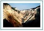
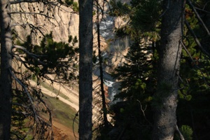
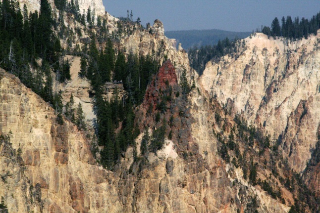
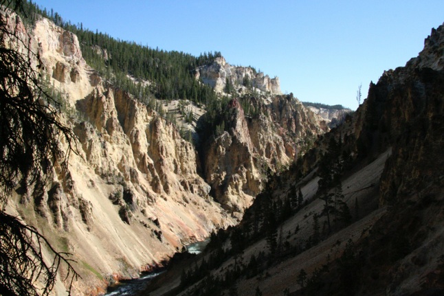
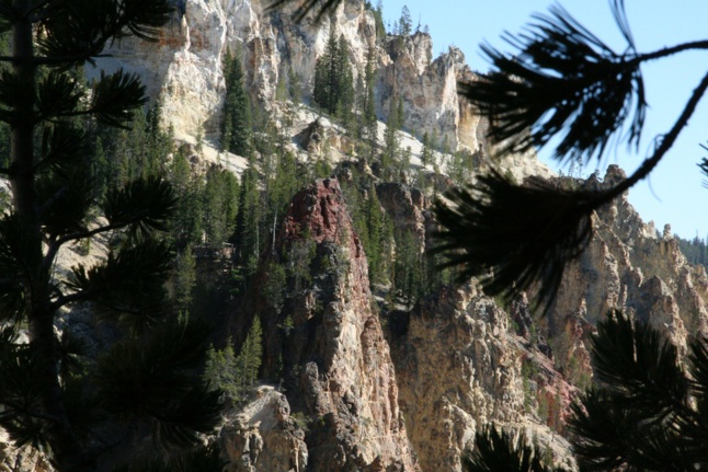
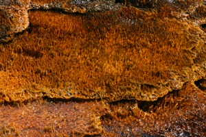
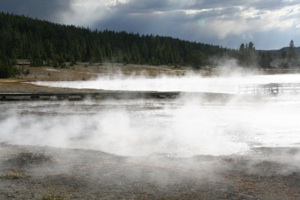
We drove through Canyon Village on Thursday to two viewpoints on the North Rim of the Grand Canyon of the Yellowstone River: Inspiration Point and Grandview Point. Water melt from glaciers carved the current V-shaped canyon. The multi-hued colors in the canyon are the result of hydrothermally altered rocks and sediments:
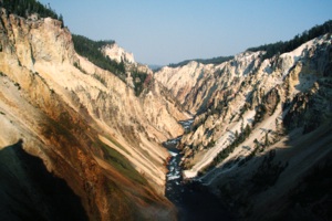
The photos in our Canyon gallery are mostly close ups, rather than long shots, as there was some smoke in the area, restricting visibility:
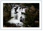
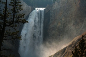
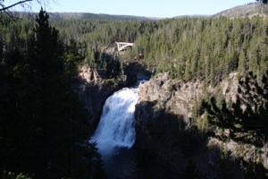
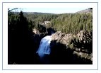
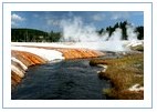
We next drove a short distance to Lookout Point and the Red Rock Point trailhead. There are four viewpoints of the Upper and Lower Falls of the Yellowstone, which should not be missed. One is easy to get to by a short trail (Brink of the Upper Falls), while the other three require a bit more effort as the trails drop down into the canyon via switchbacks and steps (but they are fairly short). These three are Red Rock Point, Brink of the Lower Falls, and, on the South Rim, Uncle Tom's Trail.
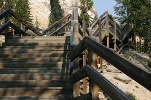
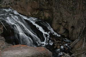
First up for us was the Red Rock Point Trail. The trail drops 500 feet into the canyon via switchbacks and wooden steps:
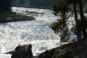
The round trip distance is about ¾ mile. The trail affords this view of the Lower Falls of the Yellowstone River, which is 308 feet high (watch the album slideshow to see the brink viewpoint to the right of the top of the falls):
The following view is looking up toward the canyon rim. Look closely at the canyon edge at the top of the picture. Several people can be seen at a lookout point on the rim, next to a tree:
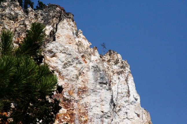
We believe this is Lookout Point, although we are not 100% sure. We think Grandview Point is out of view, behind this ridge.
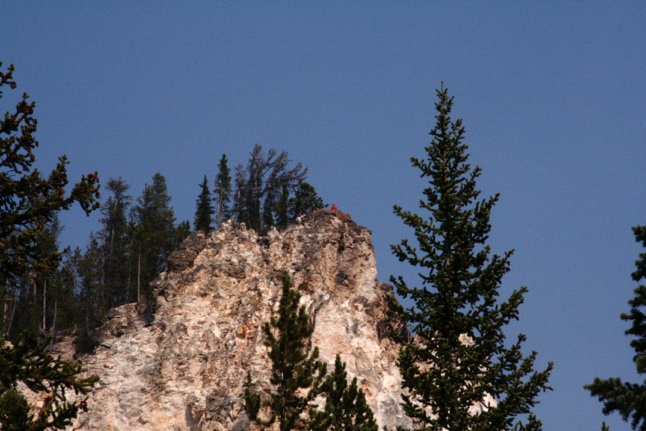
This appears to us to be another view of Lookout Point, taken from a different point on the trail. Several people can be seen on the rim in the center of the photo, one wearing a red shirt:
This is our Red Rock Point Trail gallery (watch the slideshow to see more clearly the people at the viewpoints):
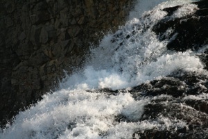
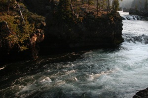
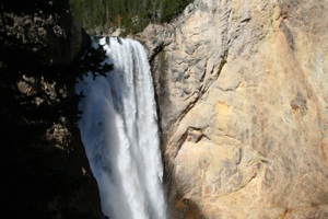
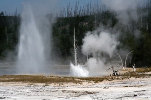
The Brink of the Lower Falls Trail was up next. This trail is also about ¾ mile round trip, and is similar to the Red Rock Point Trail, except that it drops 100 feet more into the canyon, about 600 feet total. The viewpoint at the end of the trail provides an experience that should not be missed, as one stands next to the river as it plunges over the brink, or edge, of the falls.
A canyon view along the trail:
The Yellowstone River just before it plunges over the brink:
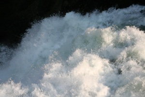
A view from the brink:
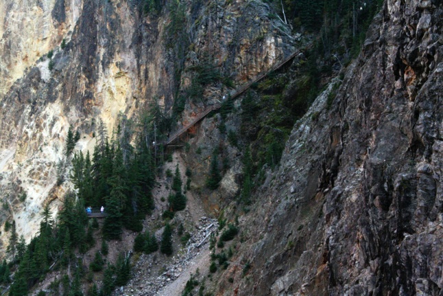
This is a view of Uncle Tom's Trail, across the canyon, taken from the brink viewpoint. Notice that there are people on the trail in the top right of the photo, all the way down to the viewpoint in the lower left portion of the photo in a cluster of trees:
How's that for a bunch of steps? The following is a view of the red rocks (center of the photo) for which the Red Rock Point Trail is named. Notice the people standing at the end of the Red Rock Point Trail, to the left of the red rocks (green trees in-between and one person is wearing a white shirt):
The last trail we took on Thursday was the Brink of the Upper Falls Trail. This is another great experience, and as I mentioned before, this trail is short and there are only a few steps.
Here's the river just upstream from the falls:
Here's the Brink of the Upper Falls, which is 109 feet high:
This is our gallery of the Lower and Upper Brinks (watch the slideshow to see more clearly people at viewpoints):
We returned to an empty site at Norris Campground, and paid for two more nights. Three or four other campsites near ours also displayed paper plate reserved signs. (Hee, hee….)
We did some other stuff the next day (Friday) so I'm going to skip ahead to Saturday, when we returned to the Canyon area. On this day we went to the opposite side of the canyon, or the South Rim. We stopped at the first viewpoint, a view of the Upper Falls:
A park ranger was forming a group for a guided tour of a portion of the South Rim Trail, so we joined up. He was retired and now worked summers only at Yellowstone. He was quite knowledgeable about the history, geology, and plant and animal life of the area.
We learned that wolves and mountain lions had been totally eradicated from the park. Wolves have been re-introduced to the park, and there are now a number of packs that are doing nicely. Apparently this year had been good with a number of pups surviving. (I'll mention a wolf later)
Mountain lions returned on their own. I believe he said that 18 now used the park as all or a portion of their range.
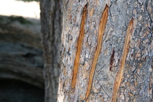
He pointed out bear claw marks on a tree:
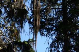
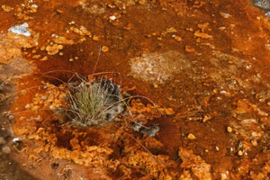
I believe the ranger called this "buffalo hair." I think it's an air plant like Spanish moss. I Googled it but didn't find any info in a quick review of the hits:
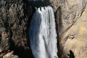
This is a view of the Lower Falls:
Here's our photo gallery from the guided tour:
Shortly after 1900, "Uncle" Tom Richardson began taking visitors down into the canyon, in the vicinity of the current Uncle Tom's Trail, on steps and rope ladders. I don't have a distance on this trail, but it descends about 500 feet. The trail provides a great view of the Lower Falls (watch the gallery slideshow to see the brink viewpoint):
Red Rock Point is in the center of this photo, across the canyon:
Here's a close up of the point. The horizontal railing of the Red Rock Point Trail Viewpoint can be seen to the left of the point (half way between the base of the red rock and the tree branch in the foreground):
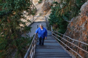
Uncle Tom's Trail now consists mostly of perforated steel steps:
You may notice in the following photo gallery from Uncle Tom's Trail that the air is clearer than it had been two days prior (watch the slideshow to see people more clearly at viewpoints):
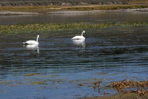
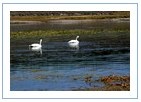
We drove south along the Yellowstone River toward Yellowstone Lake. We saw some swans:
and a herd of buffalo (OK, OK, I know: bison) walking to the water:
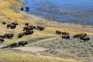
During our four days at Yellowstone, we saw buffalo all over the place; just taking their time, walking wherever they wanted. Once we saw a huge fellow walking right down the stripe in the middle of the road. Of course, all cars had to stop. He really towered over one car that he passed.
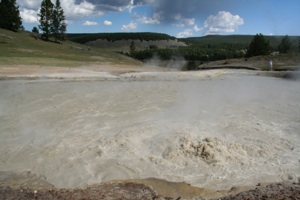
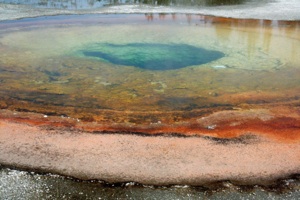
We took a 2/3-mile trail at the mud volcano area. The mudpots, which are acidic hot springs with a limited water supply, are difficult to photograph with a still camera, because of their color:
Here are our photos taken from Canyon Village to Yellowstone Lake:
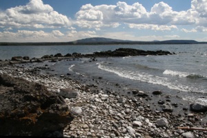
For about 20 miles between Lake Village and West Thumb, the road travels along the west bank of Yellowstone Lake. The area of the lake is about 130 sq. mi. We drove the Gull Point Road, and stopped along the main road several times to take pictures. Here's one spot:
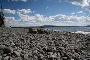
Hmmmm. Quite a few rocks. I was sure there was a lake there, somewhere. We don't know exactly … uh … we have no clue where these photos were taken. The time stamps on the photos show 1 hour 20 minutes from the mud volcano area, and a half hour from West Thumb Geyser Basin, but I'm sure we ate lunch sometime in there, so….
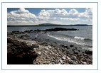
The spot is called Pumice Point, but it's not on the map. It appears to me to be near the neck of West Thumb. It's named for the little finger of pumice sticking out into the lake:
Here's the gallery:
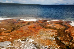
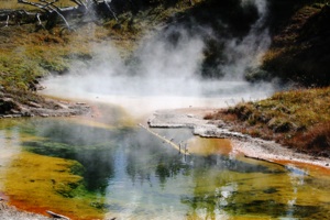
West Thumb is a … er … thumb ... of water sticking out on the west side of Yellowstone Lake. West Thumb Geyser Basin is really colorful and quite interesting as the water from the thermal features flows into Yellowstone Lake:
We took the inner loop trail, which the map shows as ¼ mile, but it looks a bit longer than that to me:
Our West Thumb gallery:

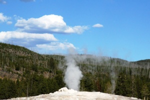
We continued on to Old Faithful, where we watched the eruption for the second time. There is a very large semi-circle of benches around the geyser. The first time we watched, on Friday, we sat on the east side, with the wind blowing toward us, so we saw mostly steam.
The average interval between eruptions for Old Faithful is 92 minutes, varying from 51 to 120 minutes. A predicted eruption time is posted in the visitor center, given as a range.
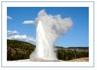
This time we watched from the far west side, with the wind blowing away. Here's Old Faithful, just getting started:
and here she is under full eruption:
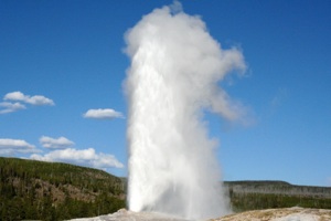
This is where we saw our first moose. No, take that back. It was a stuffed moose. A little girl, Rose, was playing a game with her dad, with her stuffed moose, while we waited. Old Faithful was a little late, erupting about 20 minutes after the end of the predicted range.
Here's a gallery with several photos of this eruption:
We then returned to the campground.
The day before (Friday) we watched Old Faithful in the morning, and then toured all the Geyser Basins in the area, gradually working our way north to Madison, then back to Norris. So I'm presenting the descriptions and photos in order in a big loop which actually took us three days to complete: east from Norris to the Grand Canyon of the Yellowstone, south to Yellowstone Lake and West Thumb Geyser Basin, west to the Old Faithful area, then north.
On Saturday we actually saw Kepler Cascades of the Firehole River before Old Faithful, but I included in this album for some unknown reason:
There are so many thermal features and trails at the Old Faithful area, it difficult to know how far one has actually walked, but I'll guess about three to four miles (and we skipped a few). So, we visited the Upper Geyser Basin (Old Faithful is here), including Black Sand Basin (1/2-mile trail) and Biscuit Basin (1/2-mile trail); Midway Geyser Basin; and Lower Geyser Basin, including Firehole Lake and Fountain Paint Pot. I tried to sort them out by looking at the time stamps, but couldn't.
Here's a few sample photos:
We saw some elk near one of the boardwalks:
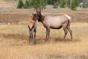
We had seen some elk at Mammoth Hot Springs, where they were eating the grass that the Rangers were watering (Hee, hee….), and one evening at dusk we saw a herd with the aid of binoculars. I think that we actually see more elk in Kachina Village, where during dry times they congregate in the park (the local name for a naturally occurring meadow) near the interstate exit. Sometimes we see them from or near our house.
We think this photo was taken along Firehole Lake Drive:
This was taken at Fountain Paint Pot (1/2 mile trail):
We think you will enjoy our gallery of all these geyser basins:
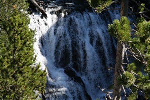
Firehole Canyon Drive is just south of Madison:
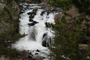
and Gibbon Falls is just east:
Here's a short gallery: