Carroll’s Photos


Posted Sunday February 10, 2008
It’s hard to believe it’s been more than three months since I have posted anything here. Good grief. It’s almost time for our 2008 camping trip!
2007/09/16
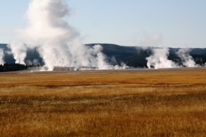
We broke camp in Yellowstone National Park for the last time and drove south to Old Faithful, where we stopped for gas. Here's one last look at the geyser basin there:
As we were leaving the area, we noticed that several cars were pulled over and people were watching an area with their binoculars. Uh, oh. Mandatory stop. We got out our binoculars and scanned the area. So it was here that we saw our lone wolf. (Hee, hee….) It looked like he was trying to dig something out of a burrow. We watched for a while, but this was apparently his unlucky day, so we drove on.
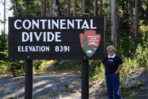
We drove east to West Thumb, and then south out of the park. In doing so, we crossed the Continental Divide three times. We think this was the highest point:
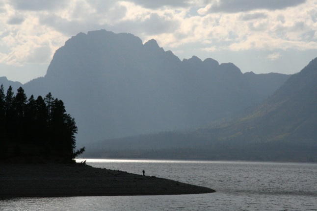
We drove south into Grand Teton National Park, where we had a reservation at Colter Bay. We pulled into our site and ate lunch, then drove a short distance to do our laundry. We returned to our site to make the bed and put all our clothes away. We're telling you all this stuff because something interesting happened later on. (Think Norris Campground.)
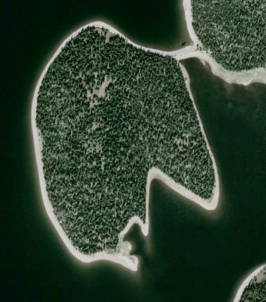
We then drove a short distance to the Lakeshore trailhead. At least, that's where we wanted to go. Not finding any signs, we walked a paved trail along the shore of Colter Bay. When we came to the end, a couple approached from the left. "Where does that go?" "Nowhere." So we went right. If we had seen the photo below, we would have known which way to go.
After we returned home, I used Google Earth to look up most of the places we went. Since most were rather remote, the Google Earth resolution wasn't good enough to figure anything out. Lakeshore Trail was an exception. In the photo below, Colter Bay is below (south of) the peninsula (almost an island). We walked the rocky shoreline of Colter Bay from the right, and then found the trail at the narrow isthmus, where we turned left and entered the forested area:
If you look closely at the photo above, you can see a meadow in the top portion of the peninsula, with a trail crossing through the center. This photo was taken there:

The trail emerges on the left (west) side of the peninsula. We think the spot is about one-third of the way up from the south end of the peninsula. We took a set of photos there, including this one:
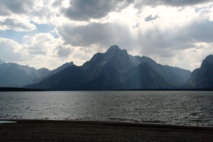
This is one spot that you feel you never want to leave. The solitude, the water (Jackson Lake), the mountains, and the sky take your breath away.
The trail re-enters the forest to emerge on the bottom (south) end of the peninsula, where we took another set of pictures, including this one:
Can you see the person standing on the shore in the photo above?
The trail then passes through the forest back to the isthmus. When we look carefully at the Google Earth photo, we think we can see bits and pieces of the trail that I described. Round trip distance from the parking lot for this easy … but spectacular … trail is about two miles.
Here's our Lakeshore Trail album. The glacier that carved out Jackson Lake left the rocks you see on the shorelines:
2007 Camping Trip
Page 5


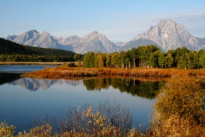
We drove south on US 89 and stopped at several turnouts to take in the spectacular views of the mountains and the Snake River as dusk was approaching. We think this photo was taken at Oxbow Bend:

Here's some photos we took at these turnouts:
And so, we returned to our campsite … and we couldn't believe our eyes! No, not a camper … hope I fooled you! (Hee, hee….) But there were 20 to 25 people sitting around in their chairs in our site. What's with these people in these national parks? They moved away pretty quickly when I started to back into the site. I probably would have been more gracious if we had not had that rather nasty run-in with the camper four nights earlier at Norris.
2007/09/17
In the morning all was still, and we found some gorgeous reflections in the Snake River:
We stopped at the Cunningham Cabin Historic Site, where somewhere between 1888 and 1890, Pierce Cunningham and his new bride staked a homestead claim. The brochure notes that this cabin is one of the best of the few remaining homestead cabins in Jackson Hole. The cabin consists of two small cabins connected by a covered breezeway:
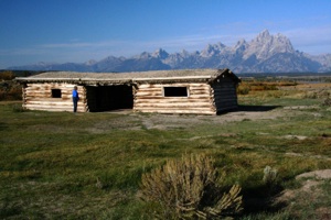
The Tetons, among the youngest on the continent, formed along a fault. The land to the west rose, forming the mountains, and the land to the east dropped, forming Jackson Hole. (Early trappers called valleys like this one "holes.") Glaciers carved the valleys between the mountains.
Cattle ranching was difficult in these high mountain "holes." During the time mentioned above, Cunningham needed to grow and store about 200 tons of hay each year to sustain his 100 head during the 6-month winter. (The growing season is less than 60 frost-free nights.)
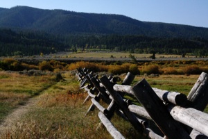
Before the invention of barbed wire, buck-and-rail fences were popular in Jackson Hole. This fencing system is named for the X-shaped braces or "cross bucks" used to support the horizontal rails:
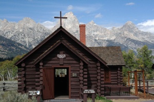
The rustic Chapel of the Transfiguration was constructed of lodgepole pine in 1925, and has pews made of quaking aspen. The window over the altar frames the Grand Tetons. Fantastic.
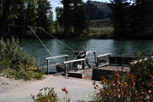
Nearby we visited the Moose Visitor Center and Menor's Ferry Historic District. (And, interestingly, this was the only place where we saw moose.) William Menor took up this homestead beside the Snake River in 1894, and constructed a ferry that became an important crossing. The ferry, a reconstruction, is set on two pontoons, and guided by a cable which keeps it from going downstream, but lets it move sideways as the current pushes against the angled pontoons:
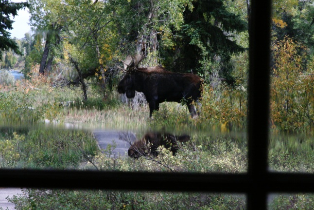
We didn't get to see the ferry in operation, since the rangers who operate it had to take up stations along a trail, as three moose had taken up temporary residence there: a bull, a cow, and her calf (not necessarily his). This view was taken from inside Maude Noble's cabin (notice the imperfections in the glass):
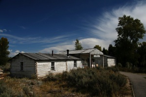
Bill Menor's cabin was built in three phases, and he opened a store (still there) in the east portion:
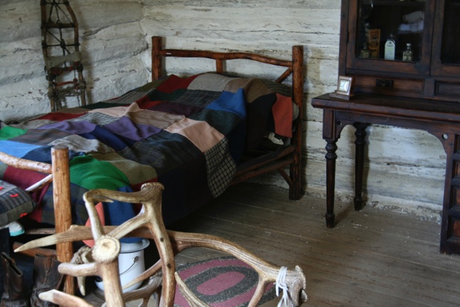
The west portion was used as a bedroom (note the elk antler chair):
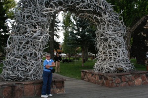
Farther south, in Jackson, we filled our propane tank and shopped at the Jackson Whole Grocer. Get it?
Antler arches are found at the four corners of the central square:
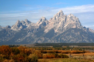
Well, we spent parts of two days in the shadow of the Tetons, but we hope to return and spend many more. There are many, many trails that we believe would make excellent day or partial-day hikes. Here's our album:
2007/09/18
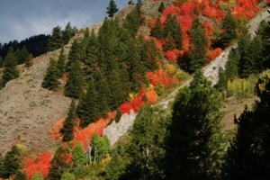
Maple trees near our campground were beautiful in their fall colors:
Here's a short album:
We continued south to Fossil Butte National Monument, in southwestern Wyoming. Here, about 50 million years ago, fossils formed in the sediments of long-gone Fossil Lake. The fossils on display in the visitor center are amazing: plants, insects, reptiles, birds, mammals, and fish. Their detail is fantastic. For example, many of the fish fossils have not only complete skeletons, but teeth, scales, and skin. We saw a palm frond fossil that looks like it might have been alive yesterday.
Several third-grade classes were visiting the center while we were there. They were keeping the teachers and rangers hopping. When it was time for the kids to visit the restrooms before leaving, it was especially interesting. Everything in there was automatic. Third graders love stuff like that. Ha, ha.
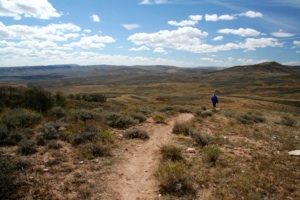
We decided to hike the one and one-half mile Fossil Lake Quarry Loop Trail because of the varied plant life along the way. This area of Wyoming is high desert, dominated by sagebrush:
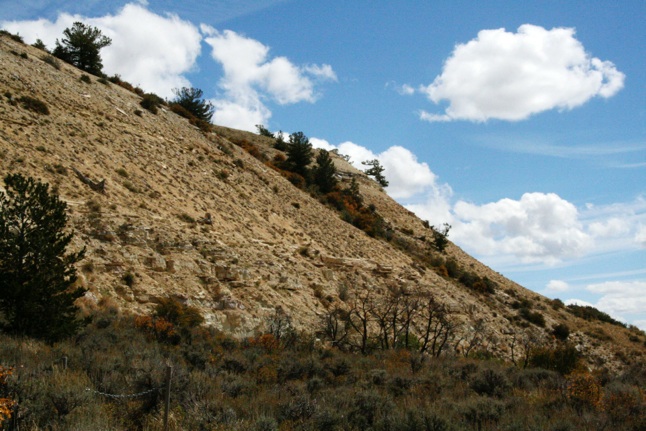
Here, a chain (lower left-hand corner of the photo) blocked a side trail that appeared to go to a small quarry at the base of the butte:
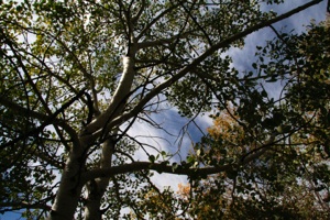
The interesting aspect of the trail is the fact that it passes through several spring-fed aspen groves. What a contrast:
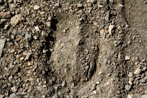
We startled some deer in one of the groves. They quickly scattered before I could photograph them. There were many hoofprints on the trail, mostly overlapping. We found one distinct print, which I photographed. I didn't think to place another object in the photo to indicate the size of the print.
Nevertheless, we stopped by the visitor center on our way out to inquire what print it might be, as we had heard one of the rangers mention that he had shown the third graders an elk print earlier in the morning. He pulled a book from the shelf, found a page of hoofprints, and compared them with our photo. Yep. Looks like an elk print. So here is the official elk print:
Our Fossil Lake Quarry Trail album:
When we left Fossil Butte, we drove to Flaming Gorge. The fastest way seemed to be to drive a short distance west into Utah, then south and southeast into Wyoming again where we picked up I-80 east. When we exited the interstate, we drove southeast into northern Utah where we camped adjacent to the reservoir at Lucerne Valley campground near the state line.
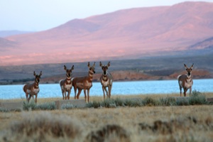
The campground was nearly deserted. Of people, that is. There were pronghorn everywhere. They were generally moving through the campground to the lake shore. After we set up we went out to photograph them:
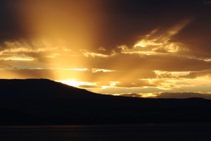
It soon became too dark to photograph the animals, so we photographed the sunset instead:
Our Lucerne album follows:
2007/09/19
The basic route this morning was to drive Utah 44 to US 191 to Vernal, stopping at overlooks of Flaming Gorge, then crossing the Uinta Mountains (u-IN-ta).

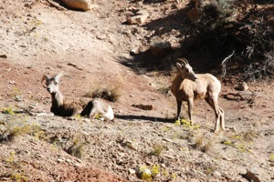
First, we drove the 10-mile mostly paved Sheep Creek Scenic Backway. The drive travels along Sheep Creek, and then climbs out of the canyon and loops back to the main highway. We didn't see any sheep on the loop, but we saw quite a few just before we turned off the main road:
At first the route travels through a beautiful riparian area along Sheep Creek:
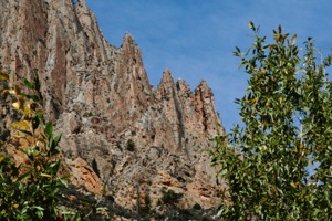
There are jagged cliffs on both sides. I included this photo because it shows an unusual formation, even though it's a bit out of focus:
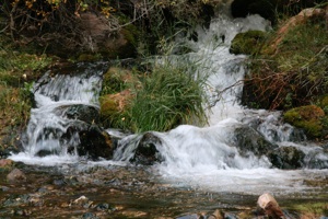
Here Big Spring flows into Sheep Creek:
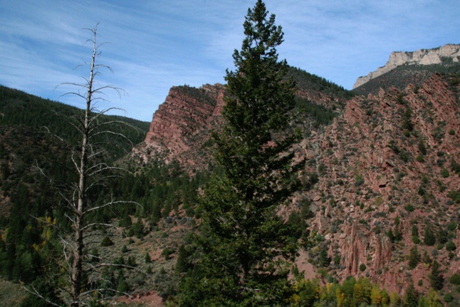
As the road climbs out of the canyon, twisted rock formations have been thrusted up vertically:
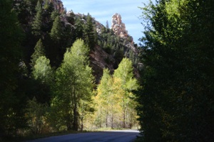
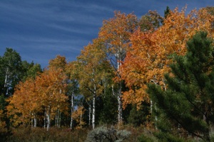
At the high end the road passes through forest and meadow:
Here's the entire Sheep Creek Canyon Scenic Drive:


