FAIRGROUNDS TRAIL
2010.08.14
This fairly new trail connects Kachina Village with the Coconino County Fairgrounds, to the north. The trail begins at the Kachina Wetlands, where there are nice views of the San Francisco peaks. It passes through a ponderosa pine forest that has been thinned, so it is similar to the forest that existed here more than 100 years ago, before fire suppression began. Ponderosa pine forests evolved with fire. Low intensity fires used to burn these forests an average of every seven years. These fires burned small trees, dead branches, pine cones, and other forest debris on the ground, but did not harm larger trees. The fires kept the forest open and park like, and grass and flowers grew in the sunlight that reached the ground.
Our cameras can’t geotag, so we gave our new Garmin GPS a test drive. We walked north on the trail for about an hour, then returned by the same route. We geotagged the photos using PhotoGPSEditor (Donationware). A few were touched up in Photoshop Elements, mostly with the PhotoTune plug-in, from onOne Software. They were then all imported into iPhoto, where they were shuffled around into the order you see below. In iPhoto,
you can view the entire route that you walked...
Click on any photo to make it larger.
Try the Slideshow. The slides look like they are resting on a black reflective table. Really cool.
Go to Zenfolio to view a full screen Slideshow. When the Gallery opens, click “Slideshow.” Press ESC to exit the Slideshow, then close the browser window to return to this page. Click HERE.
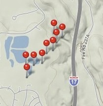
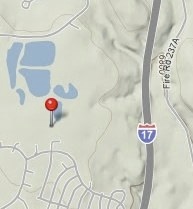
or you can view the location of any photo. This is the location of the first photo below: